Software Review
Ortelius 1.0.5

Developer: Mapdiva
Price: $99 (educational discount available)
Requirements: Mac OS X 10.5. Universal.
Trial: Feature-limited (watermarks).
A few weeks ago, my 9-year-old son had an idea for a mash-up. Not content with just playing with plastic toy soldiers, he wanted to have them engaged in a game of world domination. He needed a large world map upon which he would deploy the green soldiers on some continents and the light tan soldiers on the rest. I heartily approved the idea—what a great way to learn some history and geography! When I set about looking online for a map, much to my surprise, it was not that easy. I managed to find one after about an hour of searching. Recently I came across Mapdiva’s Ortelius, a map-making program for the Mac. You can draw maps from scratch or work off the included templates. One of the templates is a world map, with a layer of country names as an option. It would make a perfect map for my son’s game of world domination, but it is much, much more than that.
Usage
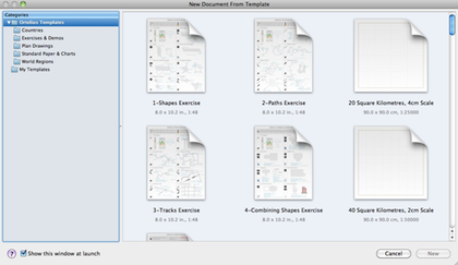
When you launch Ortelius, you are presented with a list of templates like that shown in the accompanying picture. As the left side shows, Ortelius templates are grouped by categories such as Countries and World Regions. For the screenshot, I happened to choose all templates so that the right side shows all the templates sorted alphabetically. The templates provide a quick way to get started.
Templates provide a quick way to get started, if your mapping project can use them.
Let’s say I wanted to show the US states I visited over the years. I chose one of the two USA templates, selected the states I visited, and highlighted them with an orange shade. I did not stop there and added the state names as well. I did not have to type the state names, as they are the default labels already associated with the state objects. I only needed to select New Label on the state objects to show their names. The nice thing with labels, as opposed to a text object that I add myself, is that as the main object gets moved the label follows it. For illustration purposes, in the northeast and mid-Atlantic regions, I moved New York, Maine, and others out of their positions. Note that I made use of Leader Lines to point the names to the smaller states. Lines and labels nicely followed the states as they were moved.

US states I visited.
Other attributes besides the names are associated with the objects. There are a few useful attributes included with the US states, so to better show the attributes I instead zoom in on Southeast Asia with Vietnam as the selected country. Here we can see that the Object Inspector shows information like area in square kilometers, capital, life expectancy, literacy rate, etc. Shown on the map are the capital (Hanoi), area, and population. I happen to know where in Vietnam the capital is, so stamped the general area with a star. Note that for population, I am showing it in Edit mode. I added the text label “Population (2008):” then appended to it the variable “%%pop2008”. I got the variable name “pop2008” from the Object Inspector window, Attributes pane. Should I wish to, I can add attributes like main religion, official language, independence day, etc. There is much potential in using Ortelius as an educational tool.
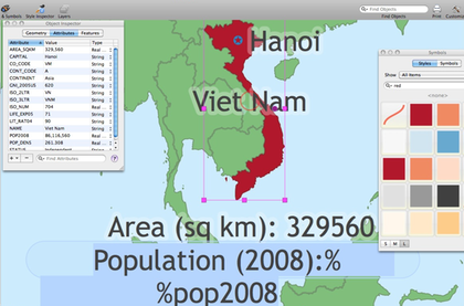
Vietnam and some useful info associated with it, like area in square kilometers and population (2008).
Main Purpose
The main use for Ortelius, of course, is making maps. Besides templates, you can have a map as a background picture to trace from or to draw on top of. Of course, the usual copyright applies, so if you use an existing map as a background graphic, be sure you have permission from the owner. You can add a background picture via the Drawing Setup menu command or use the Image Browser. With the Image Browser, just be sure to drag the picture onto your drawing and not double-click it, which in my case would just open the picture in Preview.
At some point though, you will need to make maps from scratch. You will learn to appreciate the many tools Ortelius has at your disposal, especially for making maps. Roads merge into other roads when they are drawn close enough to each other.
Traditional select tools work by drawing a shape to enclose the items to be worked on. You are probably familiar with, say, highlighting an area in Photoshop to apply some effects to it. Since Ortelius works closely with lines that represent roads, it has a special select tool called linear select. For example, to turn a part of a road into a bridge, you would select the part with the linear select tool, then select Insert Special ‣ Bridge. Similarly, you can use the linear select tool to highlight a portion of the road to change its color to indicate a different kind of pavement.
Symbols of many kinds are plentiful; just be sure to uncheck the option to show Actual Size or Smaller symbols to see them at their maximum sizes.
Ortelius produces vector lines or Bézier curves so that after the lines are drawn, you can adjust them by dragging the many anchor points to get the lines to fit what you envisioned. If adjusting existing points does not do the job, you can add or remove points. Likewise, although roads tend to automatically merge together when they intersect, if they do not merge you can force the merger by joining them. In my experience, most of the time they do not merge on their own only because I unwittingly created them on different layers. That is right, to help you better organize the various elements of your map, Ortelius lets you have layers. You typically would have a layer for roads and tracks, one for text, and perhaps one for buildings. Objects can be moved to another layer, and if you prefer not to have to click on a layer to select its objects, you can enable Auto-Activate Clicked Layer.

A simple map showing roads that merged and symbols for trees, houses, and activities, along with the Style and Symbol window.
Import/Export
While making your own maps can be exciting and educational, you may work in an office that needs to plot tons of data, so much that placing the symbols by hand is impractical. Governments and companies already have such data professionally prepared in the form of shapefiles. There are shapefiles for all kinds of data, including airports, volcanoes, and climates. Web sites like NationalAtlas.gov even have them available for free. Ortelius supports the use of shapefiles, and I was able to make a map showing Amtrak train stations in the US. Matching the shapefile data to a template map requires a little more skill that I do not yet possess so the overlaid data does not line up with the map, but you get the idea.

A map showing Amtrak stations made from freely available shapefiles and an Ortelius template.
As already mentioned, Ortelius can import bitmap formats like JPEG and TIFF for use as a background. Supported export formats also include the typical ones, but layered PDF is the recommended option. After all, Ortelius produces vector results, which can be resized and adjusted without loss of quality. I think it is wise to support the PDF standard instead of having specific vector formats as export options. Unfortunately, I do not own any of the popular vector programs, such as Adobe Illustrator, to see how well PDF exported from Ortelius performs in these other applications.
Documents Galore
Ortelius is a massive program chock full of features. I was able to find my way around most of the time, but the multiple forms of documentation in Ortelius help a lot. For starters, there is the standard Apple Help, although I find it distracting when it goes outside of the current application’s help file. If you go to Mapdiva’s Web site, you can view the many short videos that progressively take you from the basic tasks to the more advanced ones. Last, and my favorite, are the PDF documents, one to get you up and running and the other covering every facet of the application. If all that is not enough, you can also use Mapdiva’s Web forum to exchange ideas and questions.
Minor Issues
Ortelius does so much so easily, but I do have some very minor issues with it. Ortelius makes it difficult to change a built-in style to prevent unintentional global changes to other documents. You would have to unlock the style and confirm a dialog box before you can do so, even before you specifically select a style, i.e. the same security measure is in place for even the Basic Track. If possible, I think if the Basic Track should somehow be reset with each new document and be allowed to be adjusted without first requiring it to be unlocked. The alternative would be for the user to create his own Basic Track, but the typical user getting started with Ortelius most likely would not know that.
The other minor issue is when a large map has all the object names shown, the names would be of the same size regardless of the sizes of the objects. One example is the world map, where countries with small area getting the same large text that is probably larger than the countries themselves. It would be nice if the smaller countries were assigned smaller text or had their names floating nearby with leader lines pointing back to the countries.

A very minor issue with maps having many objects is that the labels can be unreadable.
Conclusion
Mapdiva has a winner on its hand. For now, Ortelius has found a niche market to fill. There are some Mac map-making programs out there, but none in the price range or that possess the features found in Ortelius. With the specific map tools found in Ortelius, it is easy to make maps, whether from templates or imported bitmaps, or even if you have to start with a blank page. You can take mapping even further by importing shapefiles, many of which are freely available on the Web. If you have a mapping need, Ortelius makes an excellent choice.
![]() Copyright © 2010 Linus Ly. Reviewing in ATPM is
open to anyone. If you’re interested, write to us at reviews@atpm.com.
Copyright © 2010 Linus Ly. Reviewing in ATPM is
open to anyone. If you’re interested, write to us at reviews@atpm.com.
Reader Comments (0)
Add A Comment